Having lived through at least four extremely memorable floods on Alabama’s Weiss Lake, I have become somewhat of an authority on flood forecasts – a flood geek if you will! While not all Alabama lake’s are known for flooding, Neely Henry Lake is a very stable lake, others were specifically designed for flood control, like Weiss Lake. Flood control lakes were designed to prevent flooding in major urban areas downriver, much to the chagrin of local lakefront owners on occasion. But to own a piece of heaven comes with a price, and flooding is a not-too-common, albeit costly bill that comes due. Here’s some news coverage of the 2021 flood on Weiss Lake.

So how do I know if it’s going to flood on any given lake in Alabama? My crystal ball is fairly accurate but my cell phone is a heck of mind reader for fickle lakes. When flood waters are are their way to your lakefront hamlet point your interwebs device to the National Weather Service’s Advanced Hydrologic Prediction Service or simply google “NOAA Weiss Lake” (or whatever Alabama lake you’re concerned with). Through the last two floods (2015 and 2019) this service was accurate not only to the 10th of an inch about water depth, but also as to when the lake would reach its peak or “crest”.
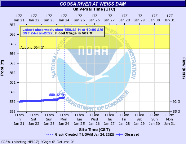
It’s important to note that this site only predicts floods when, you guessed it, a flood is coming! Otherwise you get the image above showing current depth conditions. This is my goto for up-to-date flood information. I don’t pay attention to newscasters or Facebook “experts”. Stick to the raw data and you’ll know if it’s time to break out the waders and yard rakes, or time to head for the high ground!
by: Clark Stewart, The Alabama Lake Guru