
Weiss Lake in Alabama is a vast and captivating destination for outdoor enthusiasts, anglers, and nature lovers. Whether you’re planning a fishing expedition, a leisurely day by the water, or a scenic hike or touring Lakefront homes for sale, having access to reliable maps and resources can greatly enhance your experience. In this blog post, we’ll explore the wealth of interactive maps and resources available to help you make the most of your visit to Weiss Lake.
Alabama State Parks and Tourism Websites
- Start your journey by visiting the official websites of Alabama’s State Parks and Tourism Department. These websites often provide detailed maps, brochures, and valuable information about Weiss Lake and its surrounding areas.
- You can find information on camping sites, hiking trails, boat ramps, and other points of interest.
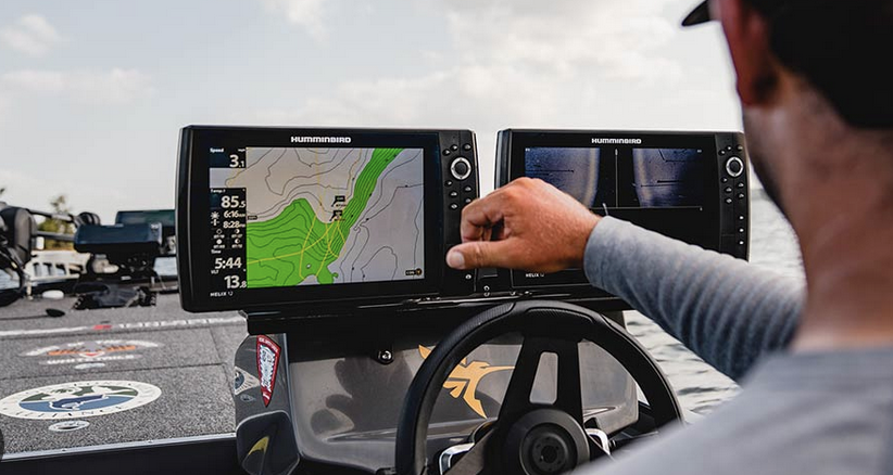
Fish Finders and Depth Maps
- Anglers will appreciate the availability of fish finders and depth maps specific to Weiss Lake. These tools can help you pinpoint the best fishing spots and understand the underwater topography.
- Websites and mobile apps like Fishbrain and Fishidy offer community-driven fishing maps and resources.
GPS Navigation Apps
- Download GPS navigation apps like Google Maps, Waze, or specialized outdoor navigation apps such as Gaia GPS. These apps can help you find your way to Weiss Lake and navigate the local roads and trails.
- Some apps even allow you to download maps for offline use, which can be particularly handy in areas with limited cellular coverage.
Interactive Trail Maps
- If you plan to explore the hiking trails around Weiss Lake, consider using interactive trail maps. Websites like AllTrails and the official website of Lake Guntersville State Park offer detailed trail maps, ratings, and user reviews.
- These resources can help you choose the right trail for your skill level and preferences.
Lake Depth and Topography Maps
- Understanding the lake’s depth and topography is essential for boaters and anglers. Websites like Navionics and the Alabama Power Shorelines app provide interactive lake maps with depth contours.
- These resources are valuable for finding underwater structures and fishing hotspots.
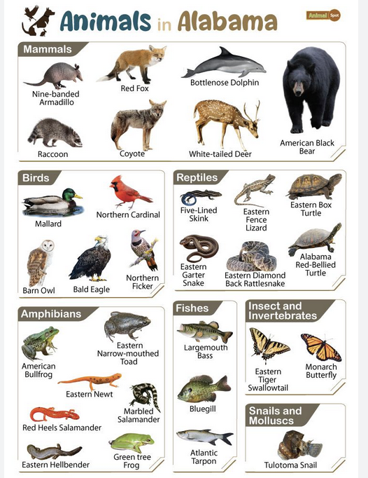
Interactive Wildlife Spotting Guides
- If bird-watching or wildlife viewing is your passion, interactive guides can help you identify the local fauna. Websites like Audubon’s Bird Guide and iNaturalist allow you to record and share your observations.
- These resources can enhance your experience as you spot and document the diverse wildlife around Weiss Lake.
Local Tourist Information Centers
Don’t forget to visit local tourist information centers, especially if you’re on-site. They often provide printed maps, brochures, and personalized advice to make the most of your visit to Weiss Lake.
Conclusion:
Weiss Lake, Alabama, offers a wealth of outdoor opportunities, and having access to interactive maps and resources can significantly enhance your experience. Whether you’re a fishing enthusiast, a hiker, or simply looking to explore the natural beauty of the area, these tools can help you navigate and discover the wonders of Weiss Lake with confidence. So, don’t forget to explore these valuable resources before and during your visit!
Published by Clark Stewart with Lakefront Living Realty- https://bit.ly/m/LakeGuru